Protecting Wolf Creek Pass from the proposed Village at Wolf Creek development has been one of San Juan Citizens Alliance’s priorities for almost 40 years. When Pagosa Springs local Deirdre Rosenberg reached out with a photography project, we leapt at the opportunity to collaborate and tell the story of what makes Wolf Creek Pass so captivatingly unique and worth protecting.
At almost 11,000 feet in elevation, Wolf Creek Pass receives more snowfall than any other pass in Colorado. Between the altitude, the snow, the steep terrain, and State Highway 160 winding its way along the Continental Divide, there are many forces that would separate people, animals, ecosystems, and resources. Yet Wolf Creek Pass spans these features, connecting what would otherwise be isolated islands into a grander, richer, and more complex landscape.
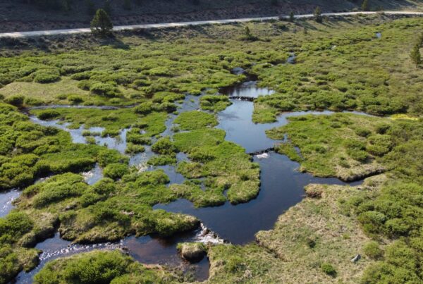
Perched atop the Continental Divide, snowmelt from Wolf Creek Pass feeds the headwaters of two mighty rivers. From its apex the Rio Grande cascades east and south to the Atlantic Ocean, and the San Juan River flows southwest, joining the Colorado River in Utah on its journey to the Pacific. As the snowpack on the pass melts, it recharges both ground and surface water. Groundwater feeds the many fens, rare and fragile alpine wetlands, that dot the marshy depressions on the pass. Fens take thousands of years to develop and are important for biodiversity. They support rare plant and animal species, cycle nutrients through the ecosystem, filter out pollutants, and function as a sink for atmospheric carbon.
While these fens are hydrologically connected to tributaries that feed the San Juan and Rio Grande Rivers, they lack a continuous surface connection to these waters. Prior to 2023, hydrological connection to a navigable waterway was sufficient to afford wetlands federal protections under the Clean Water Act. However, since the 2023 Supreme Court decision in the Sackett case, wetlands without surface connections are no longer jurisdictional, and can be dredged and filled without permitting from the Army Corps of Engineers. The decision put wetlands across the country, and on Wolf Creek Pass, at risk of development, with consequences for watersheds and users downstream.
Surface waters are visible from the air or on foot, and their meanderings are easier to track. As snow melts, a spider web of creeks drain the cirques and gullies along the pass. They cascade into Wolf Creek, which parallels Highway 160 westward to its confluence with the West Fork of the San Juan River. The West Fork meets the East Fork a few miles upstream of Pagosa Springs, flowing through town on its journey south to Navajo Dam, then west through Farmington, New Mexico, piercing through the Four Corners on its way to the Colorado River at Lake Powell.
On the eastern side, meltwater pours into the South Fork of the Rio Grande through the aptly named town of South Fork, through the town of Del Norte and onward through the high and dry San Luis Valley, where it doglegs south through New Mexico and follows the Texas-Mexico border all the way to the Gulf.
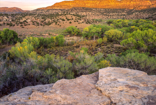
Water is life, nourishing the mixed conifer forests that carpet the pass, and the flora, fauna, communities and agriculture downstream.
The rivers support millions of people, numerous Pueblo and Tribal Nations, cities and towns, ranches and farms, and countless ecosystems and species.
All this demand, coupled with persistent drought and a changing climate, put pressure on the rivers and the watersheds they sustain. When there is more water allocated than water in the rivers, “over-appropriation,” little to no water is left for environmental flows. In dry years, the Rio Grande may not reach the Gulf, and the Colorado runs dry before reaching Mexico.
Water shapes the surrounding topography, establishing and reinforcing steep elevation gradients between the lofty highlands and lush valleys. Herds of migratory elk and mule deer take advantage of the precipitous terrain to survive Colorado’s harsh seasonal changes. In summer they give birth and feast on grasses and forbs high on the pass, putting on fat stores to survive the winter. As the
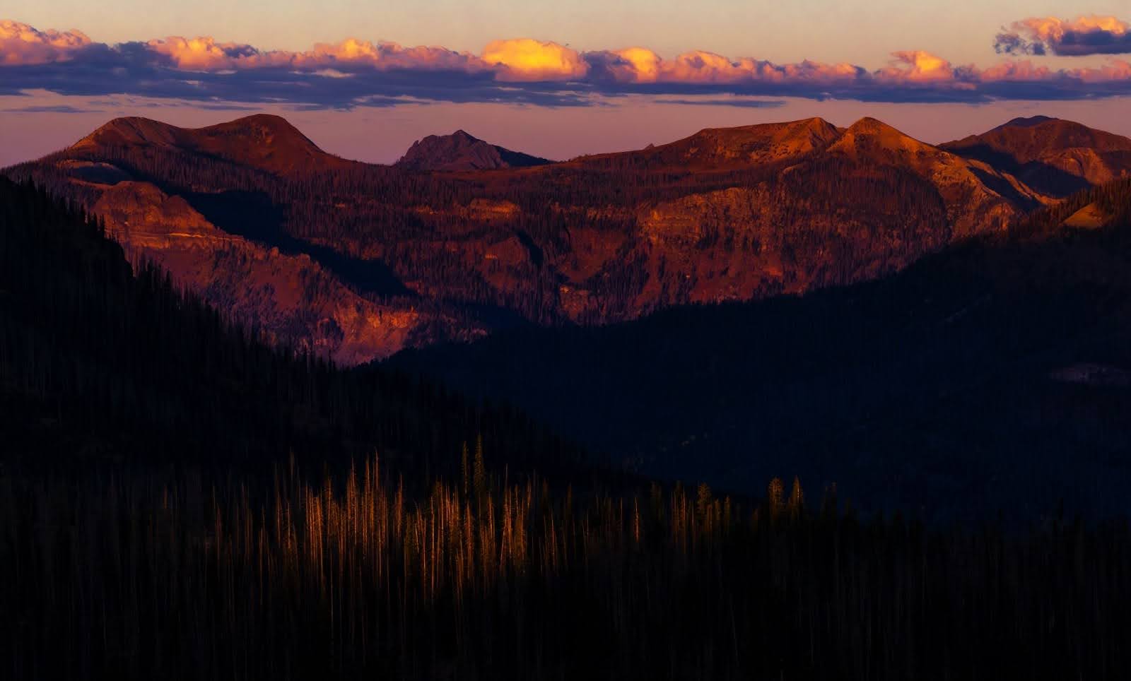
Mountain passes are saddle-like features between ranges which serve as passageways that allow humans, animals, water, and nutrients to flow across ridgelines and between basins. In mountain towns across southwest Colorado we are intimate with mountain passes. Their names roll off our tongues like cherished friends or respected adversaries: Lizard Head, Coal Bank, Molas, Red Mountain, Cumbres; they orient us to our surroundings like a constellation on the landscape.
snow begins to fly, they descend through valleys and drainages to winter range in the basins. There they subsist on meager forage and starve down their fat stores, avoiding the deep snowpack that accumulates in the highlands. As snow melts in the spring, vegetation begins to green up, first in the basins, then higher and higher bit by bit. The herds begin their journey upward towards their summer range, and the cycle begins anew as it has for countless generations.
10,000 YEARS OF INDIGENOUS INFLUENCE
Indigenous peoples have attuned to these cycles since time immemorial, following game along their migration paths from the river valleys to the Continental Divide. Humans have inhabited what is now Colorado for at least 10,000 years, evidenced by Paleo-Indian spear points dated to around the last ice age. For millennia throughout the Archaic period, native peoples established seasonal camps, hunted and gathered in the area of Wolf Creek Pass. The pass remains a site of significant cultural and historical importance to Indigenous peoples, particularly the Utes, who have hunted, gathered, and camped in the region for thousands of years. The high-altitude landscapes, abundant resources, and strategic location of Wolf Creek Pass made it a vital corridor for Indigenous communities, facilitating trade, migration, and cultural exchange.
Contemporary Tribal Nations retain strong cultural and spiritual connection to the region. In 2022, the Southern Ute Indian Tribe partnered with state and federal agencies to establish a 12-million dollar wildlife overpass across Highway 160 near Chimney Rock to protect deer and elk migrations and reduce wildlife-vehicle collisions. The highway bisects a major migration corridor, and wildlife overpasses can reduce collisions by 85-90% while maintaining habitat connectivity. Innovative partnerships like these are a win-win for people and wildlife, and help repair some of the habitat fragmentation caused by human infrastructure and disturbance.
A HIGHWAY WORTHY OF A COUNTRY SONG
Highway 160, which follows Wolf Creek eastward up to the Continental Divide and the South Fork down the other side, is a vital connector for rural southwest Coloradans. The closest town west of the pass, Pagosa Springs, is 160 miles from the nearest interstate and a five-hour drive from Denver if you’re speeding. Locals must venture over the pass to the San Luis Valley, often in hazardous conditions, before traveling north towards the Roaring Fork Valley or beyond to the Front Range. The Colorado Department of Transportation reports about a dozen semi-truck rollovers a year on Wolf Creek Pass, and cautions travelers to “Beware the Wolf!”. The treacherous route inspired a song by country singer C.W. McCall in 1975, warning listeners of its switchbacks and hairpin turns. Further development on the pass would increase traffic and pose safety risks to people as well as animals.
LYNX HAVEN
The highway partitions two great wilderness areas. To the northwest, the Weminuche Wilderness, at almost 500,000 acres, is the largest in Colorado. To the southeast, the South San Juan Wilderness spans nearly 159,000 acres. Wolf Creek Pass bridges these two islands of habitat, providing a “key linkage area” for the imperiled Canada lynx. Lynx are native to southwest Colorado, but by the 1970s they were extirpated from the region by trapping, poisoning, and habitat loss. By the end of the century, their numbers had fallen so significantly across the United States that they were federally listed as an endangered species by the US Fish and Wildlife Service. Between 1999 and 2006 Colorado Parks and Wildlife (CPW), the state wildlife agency, reintroduced 218 lynx to the San Juans, three or four at a time, from Alaska and Canada. Current monitoring from CPW suggests lynx remain in the San Juans and are successfully reproducing.
In 2024 U.S. Fish and Wildlife Service (FWS) released its final Canada lynx recovery plan, proposing critical habitat designations in Colorado for the first time in history. Critical habitat is an area designated by the federal government as essential to the survival of a species under the Endangered Species Act (ESA). FWS puts the odds of lynx surviving in western Colorado to the year 2100 at about 50%, and Wolf Creek Pass is a crucial refuge for lynx in a warming climate. But the critical habitat designation, and the ESA itself, have been increasingly politicized, and the future remains uncertain for Canada lynx.
New research from the US Forest Service, in collaboration with CPW and the University of Wyoming, recently found that land management, wildfires, and habitat alteration or loss are the biggest threats to lynx survival in western Colorado. The study captured and fitted 18 lynx with GPS collars for three years, and analyzed the resulting data against dozens of variables comparing climate, topography, vegetation, soil conditions, and human disturbance. The findings emphasized lynx avoidance of areas disturbed by humans, especially infrastructure like roads, urbanization, and ski area expansion.
A COMMUNITY ROOTED IN WILD PLACES
The communities surrounding Wolf Creek Pass are intrinsically linked to the wilderness areas and the resources they provide. Tourism and outdoor recreation are vital to the local economy, with visitors drawn to the area for skiing, hiking, fishing, and wildlife viewing. Local communities benefit from the health of the ecosystems that surround them. Clean water from the pass’s watersheds supports irrigation, drinking supplies, and recreational activities. In turn, the preservation of wildlife habitats creates opportunities for tourism, supporting jobs and fostering a deeper connection between residents and their natural surroundings.
Wolf Creek Pass, like any bridge, requires balance to maintain stability. As humans, we have the capacity and the responsibility to weigh the impacts of our decisions on our own population and the wider biotic community. The intricate web of cause and effect defines our present and shapes our future. Will the future of the pass include Canada lynx pursuing hare through powder and downed timber, bull elk in velvet grazing amongst the wildflowers, recreational access and economic stability for our communities, clean drinking water and safe roads? Humans have thrived on Wolf Creek Pass, in coexistence with our biotic community, for thousands of years. Today our own desire to possess and consume the pass’ resources presents the biggest risk to our human and non-human neighbors.
THE PROPOSED VILLAGE AT WOLF CREEK
Nearly four decades ago, Billy Joe “Red” McCombs – the Texan billionaire who built an empire spanning car dealerships, media, and sports – teamed up with Mineral County landowner Charles Leavell for a real estate investment. In 1986, the newly incorporated Leavell-McCombs Joint Venture (LMJV) swapped three parcels in the San Luis Valley for a private, 300-acre parcel atop Wolf Creek Pass in a controversial land exchange with the Forest Service. The parcel is an “inholding,” a private island in a sea of public land, isolated from Highway 160 by a strip of National Forest. It’s politically situated in Mineral County, one of the least populous counties in the state, with fewer than a thousand residents. The lot is perched on 52 acres of wetlands including 25 acres of fens, eight springs, and thousands of linear feet of streams.
LMJV initially proposed a 200-unit “village” on the parcel to serve visitors to the adjacent Wolf Creek Ski Area, a separate, family-owned hill that operates on permitted public land. But Red’s dream soon expanded into an 8,000-person luxury resort, with 3 hotels, 15 condos, 42 townhomes, 76 single-family lots, and a school, all supported by a water storage and treatment facility, a wastewater treatment plant, and a private, onsite gas-fired power plant. To top it off, 221,000 square feet of commercial space would ensure guests eat at Red’s restaurants and shop at Red’s retail establishments, instead of supporting the tourism economies of Pagosa, South Fork, and Del Norte. The Village at Wolf Creek was to be a shining metropolis to rival Aspen, five times the population of Pagosa Springs and twenty times that of South Fork.
The Village, better known locally as the “Pillage” at Wolf Creek, spurred years of environmental litigation. Conservation organizations beat back various development schemes in court, prevailing in state court in 2007, and federal courts in 2017 and 2022. Judges repeatedly ruled that the Forest Service, the agency responsible for approving access to the private parcel, failed to adequately consider the environmental impacts of development. Thirty-seven years after its initial proposal, both Leavell and McCombs have passed away, but the Village at Wolf Creek lives on. In April 2024, the 10th Circuit Court of Appeals held that the Forest Service must issue a right of way to LMJV, now a faceless legal entity, to access the site for the purpose of developing a resort. For the first time since 1986, a court paved the way for the Pillage’s construction.
As of now, the “Village” is merely conceptual. The Court has ordered the Forest Service to issue a right of way, but numerous state and federal permitting agencies must approve aspects of the development and its connection to Highway 160.
Studies indicate that the Village would increase traffic by thousands of vehicles each day. The proponents lack an adequate electric supply, and are proposing to build their own two-megawatt natural gas fired power plant, provisioned by tanker trucks filled with liquified natural gas. The Colorado Department of Transportation must ensure public safety on the highway, which could require building a major new interchange at the developer’s expense. The developers must also mitigate wildlife impacts, which could include a wildlife overpass similar to the one constructed west of Pagosa.
The Village’s exceedingly junior water rights on creeks feeding the Rio Grande are likely insufficient for their expanded plans. Irrigators on the Rio Grande and its tributaries are routinely cut off by “calls” from senior water rights holders, and this scarcity will worsen with climate change. The Forest Service admits the project will harm water quality.
Much of the property is covered in wetlands. In the wake of the US Supreme Court’s decision in Sackett, it is unclear whether the US Army Corps of Engineers would have jurisdiction over them. The State of Colorado recently passed legislation to protect wetlands no longer under federal jurisdiction. Even if the developers don’t need permits from the Army Corps, they will likely need permits from Colorado.
On top of all this, there are no emergency services available. Emergency care on the pass is currently provided by the Archuleta County Sheriff’s Office out of Pagosa Springs. Medical services are scarce. Mineral County and neighboring Hinsdale and Archuleta counties have all been flagged as Health Professional Shortage Areas by the U.S. Dept of Health and Human Services. The Village would increase Mineral County’s population tenfold. If it’s constructed, it will be local residents who shoulder the harm of degraded wildlife habitat, water, and air quality, more traffic and risk on our roads and pressure on public services. And, less tangible but nonetheless important, the loss of character as a locally cherished ski area and backcountry playground becomes engulfed in yet another “luxury” resort.